Students are unable to mug up the facts when it comes to social science they are unable to get the brief and updated material. We in this article will provide you with a brief introduction of class 9 geography chapter 3 Drainage along with Ncert solutions so that students can take the gist of the facts and will easily understand the basic concept of the chapter Drainage. The chapter mainly tells about the river systems and the role of rivers in our economy. Let’s begin with a brief introduction and get a clear idea of all the terms related to class 9 Drainage.
Drainage Class 9
- The term drainage describes the river system of an area. Small streams flow from different directions to join the main river and ultimately drain into a big river, sea, or ocean.
- The area drained by a single river system is called a drainage basin.
- Any upland or any mountain separating two different drainage basins is known as a water divide.

Drainage Systems in India
The Indian rivers are divided into two major groups:
- The Himalayan rivers
- The Peninsular rivers
| The Himalayan rivers | The Peninsular rivers |
| Most of the Himalayan rivers are perennial which means they are filled with water throughout the year and in all seasons. | Peninsular rivers are seasonal. |
| These rivers receive water from rain as well as from melted snow from high mountains. | The rivers depend on rainfall. |
| Two major Himalayan rivers, the Indus and the Brahmaputra originate from the north of the mountain ranges. | Most of the rivers of peninsular India originate in the Western Ghats and flow towards the Bay of Bengal. |
| The Himalayan rivers have long courses from their origin to the outflow. | These rivers have shorter and shallower courses as compared to Himalayan rivers. |
The Himalayan Rivers
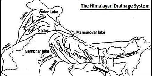
The major Himalayan rivers are the Indus, the Ganga, and the Brahmaputra. A river along with its tributaries may be called a river system.

1) The Indus River System
- Indus is one of the longest rivers in the world with a total length of 2900 km.
- The river Indus originates in Tibet, near Lake Mansarovar.
- It enters India in the Ladakh district of Jammu and Kashmir
- The Satluj, the Beas, the Ravi, the Chenab, and the Jhelum join together and enter the Indus in Pakistan.
2) The Ganga River System
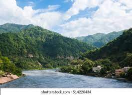
- The source of the Ganga called the ‘Bhagirathi’ is fed by the Gangotri Glacier and joined by the Alaknanda at Devprayag in Uttarakhand.
- The Ganga emerges from the mountains to the plains at Haridwar, also known as Maa Ganga.
- The Ganga is joined by many tributaries from the Himalayas, such as the Yamuna, the Ghaghara, the Gandak, and the Kosi.
- The length of the Ganga is over 2525km.

3) The Brahmaputra River System
- The Brahmaputra rises in Tibet east of Mansarovar lake.
- It is slightly longer than the Indus.
- On reaching the Namcha Barwa (7757 m), it takes a ‘U’ turn and entering India in Arunachal Pradesh, called the Dang.
- Dang is joined by the Dibang, the Lohit, and many other tributaries to form the Brahmaputra in Assam.
The Peninsular Rivers
The main water divide in Peninsular India is formed by the Western Ghats. The major rivers of the Peninsula, such as the Mahanadi, the Godavari, the Krishna, and the Kaveri flow eastwards and drain into the Bay of Bengal. These rivers make deltas at their outflows. The Narmada and the Tapi are the only long rivers that flow westward and form estuaries.

1) The Narmada Basin
- The Narmada has its origin in the Amarkantak hills in Madhya Pradesh.
- The Narmada flows through a deep gorge at the ‘Marble rocks’ near Jabalpur.
- The Narmada basin covers parts of Madhya Pradesh and Gujarat.
2) The Tapi Basin
- The Tapi rises in the Satpura ranges, in the Betul district of Madhya Pradesh.
- Its basin covers parts of Madhya Pradesh, Gujarat, and Maharashtra.
3) The Godavari Basin
- The Godavari is the largest Peninsular river. Its length is about 1500 km.
- It rises from the slopes of the Western Ghats in the Nasik district of Maharashtra.
- The Godavari is joined by several tributaries, such as the Purna, the Wardha, the Pranhita, the Manjra, the Wainganga, and the Penang.
- It is also known as Dakshin Ganga
4) The Mahanadi Basin
- The Mahanadi originates in the highlands of Chhattisgarh.
- The length is about 860 km.
- Its drainage basin is shared by Maharashtra, Chhattisgarh, Jharkhand, and Odisha.
5) The Krishna Basin
- It rises from a spring near Mahabaleshwar.
- The length of the river is about 1400 km.
- Its drainage basin is shared by Maharashtra, Karnataka, and Andhra Pradesh.
6) The Kaveri Basin
- The Kaveri rises in the Brahmagiri range of the Western Ghats.
- The total length of the river is about 760 km.
- Its basin drains parts of Karnataka, Kerala, and Tamil Nadu.
Some smaller rivers are flowing towards the east. Some of them are:
- The Damodar
- The Brahmani
- The Baitarani
- The Subarnarekha
Lakes
India has many lakes. These lakes differ from each other in size and other characteristics.
- Most lakes are permanent and some of them are seasonal depending on rainfall.
- Some lakes are the result of the action of glaciers and ice sheets
- Some have been formed by wind, river action, and human activities hence are called artificial lakes.

These lakes are attractive for tourists in places like Srinagar, Nainital. Different lakes are:
- A meandering river across a floodplain forms cut-offs that develop into ox-bow lakes.
- Spits and bars form lagoons in the coastal areas. Eg: the Chilika lake, the Pulicat lake, and the Kolleru lake.
- Lakes in the region of in, land drainage is sometimes seasonal. For example, Sambhar Lake in Rajasthan is a saltwater lake.
- Most of the freshwater lakes are in the Himalayan region. They are of glacial origin. The Wular lake in Jammu and Kashmir formed due to tectonic activities.
Importance of Lakes
Lakes are useful to human beings in many ways:
- Lakes help to regulate the flow of a river.
- These lakes also prevent flooding.
- During the dry season, these lakes help to maintain an even flow of water.
- Lakes can also be used for developing hydel power.
- Lakes moderate the surrounding climate, maintain the aquatic ecosystem, enhance natural beauty, and provide recreation.

Role of Rivers in the Economy
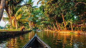
- Rivers have been of fundamental importance throughout human history.
- Water from rivers is a basic natural resource, essential for various human activities.
- Rivers are used for irrigation, navigation, hydropower generation, etc.
River Pollution
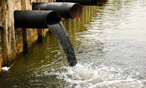
The growing domestic, municipal, industrial, and agricultural demand for water from rivers is affecting the quality of water and is responsible for the contamination and pollution of these rivers. Rivers are getting polluted as a heavy load of untreated sewage and industrial effluents are getting emptied into the rivers. Concern over rising river pollution led to the launching of various action plans to clean the rivers using many techniques.

NCERT Solutions For Class 9 Drainage
Q1. Choose the right answer from the four alternatives given below.
(i) Which one of the following describes the drainage patterns resembling the branches of a tree?
(a) Radial
(b) Dendritic
(c) Centrifugal
(d) Trellis
Answer (b) Dendritic
(ii) In which of the following states is the Wular lake located?
(a) Rajasthan
(b) Uttar Pradesh
(c) Punjab
(d) Jammu and Kashmir
Answer (d) Jammu and Kashmir
(iii) The river Narmada has its source at
(a) Satpura
(b) Brahmagiri
(c) Amarkantak
(d) Slopes of the Western Ghats
Answer (c) Amarkantak
(iv) Which one of the following lakes is a saltwater lake?
(a) Sambhar
(b) Dal
(c) Wular
(d) Gobind Sagar
Answer (a) Sambhar
(v) Which one of the following is the longest river of Peninsular India?
(a) Narmada
(b) Krishna
(c) Godavari
(d) Mahanadi
Answer (c) Godavari
(vi) Which one amongst the following rivers flows through a rift valley?
(a) Mahanadi
(b) Tungabhadra
(c) Krishna
(d) Tapi
Answer (d) Tapi
Q2. Answer the following questions briefly.
(i) What is meant by a water divide? Give an example.
- i) Any upland or a mountain separating two adjoining drainage basins is known as a water divide. An example of a water divide in the Western Ghats.
(ii) Which is the largest river basin in India?
(ii)The Ganga river basin is the largest in India.
(iii) Where do the rivers Indus and Ganga have their origin?
(iii)The Indus river has its origin in Tibet near the Mansarovar Lake while the Ganga River has its origin in Gangotri Glacier in Uttaranchal.
(iv) Name the two headstreams of the Ganga. Where do they meet to form the Ganga?
(iv)Alaknanda and Bhagirathi are the two headstreams of the Ganga. They both meet to form the Ganga at Devprayag.
(v) Why does the Brahmaputra in its Tibetan part have less silt, despite a longer course?
(v)The Brahmaputra river also known as Tsangpo in Tibet, receives a very little volume of water in Tibet so it carries little silt. But once it enters India, Brahmaputra is fed by heavy rains, and it carries a lot of water and silt.
(vi) Which two Peninsular rivers flow through trough?
(vi)The two rivers that flow through troughs are Narmada and Tapi. They form estuaries as they flow westward.
(vii) State some economic benefits of rivers and lakes.
(vii) River is very beneficial for agricultural purposes and generating hydroelectricity. It Provides fisheries and inland channels for transport and helps maintain aquatic systems and useful for navigation purposes. Lakes like the Sambhar Lake provide edible salt. They also help develop tourism and provide recreation.
Q3. Below are given names of a few lakes of India. Group them under two categories
– natural and created by human beings.
(a) Wular
(b) Dal
(c) Nainital
(d) Bhimtal
(e) Gobind Sagar
(f) Loktak
(g) Barapani
(h) Chilika
(i) Sambhar
(j) Rana Pratap Sagar
(k) Nizam Sagar
(l) Pulicat
(m) Nagarjuna Sagar
(n) Hirakund
Natural Lakes: Wular, Dal, Nainital, Bhimtal, Chilika, Pulicat, Sambhar, Barapani, Loktak
Created by human beings: Gobind Sagar, Hirakud, Rana Pratap Sagar, Nagarjuna Sagar,Nizam Sagar
Q4. Discuss the significant difference between the Himalayan and the Peninsular rivers.
| The Himalayan rivers | The Peninsular rivers |
| Most of the Himalayan rivers are perennial which means they are filled with water throughout the year and in all seasons. | Peninsular rivers are seasonal. |
| These rivers receive water from rain as well as from melted snow from high mountains. | The rivers depend on rainfall. |
| Two major Himalayan rivers, the Indus and the Brahmaputra originate from the north of the mountain ranges. | Most of the rivers of peninsular India originate in the Western Ghats and flow towards the Bay of Bengal. |
| The Himalayan rivers have long courses from their origin to the outflow. | These rivers have shorter and shallower courses as compared to Himalayan rivers. |
Question 5. Compare the east-flowing and the west-flowing rivers of the Peninsular plateau.
| East Flowing Rivers | West Flowing Rivers |
| Major rivers flowing eastwards: Mahanadi, Godavari, Krishna, Kaveri | Only two long rivers flow westwards: Narmada, Tapi |
| These rivers drain in the Bay of Bengal. | These rivers drain in the Arabian sea. |
| Carry greater amount of sediments, so form deltas at their mouths | Carry lesser amount of sediments, so form estuaries at their mouths |
| Has many tributaries | Lesser number of tributaries |
| These rivers flow not through very deep canals. | These rivers flow in troughs. |
Question 6. Why are rivers important for the country’s economy?
Importance of rivers:
- It is a source of natural fresh water and is required for the survival of most aquatic as well as all animals including humans.
- The water from the rivers is used for various domestic, industrial, and agricultural purposes.
- The presence of rivers boosts trade and commerce by helping in the easy transport of goods. Also used for hydel power.
- It is also used for navigation and transport, a boon for commercial activities.
- It also provides fishing and great scenic and recreational value. Thus, they serve as good tourist spots.

Conclusion
To conclude, We have penned down NCERT Solutions for class 9 geography chapter 3 Drainage along with a short introduction of the Indian drainage system with the river map of India. The students will know the concept in brief and they will be able to solve the exercises easily.

